| Home | Temple Videos | On-line Books |
Herod's Temple in 3D | About the Author |  |
 |
Ancient Water System for Temple revealed on the Temple Mount
Norma Robertson (Jan 10, 2016)
Is this something no one has seen before? No, but it is the first time
it has
been recognized and understood for what it was.
I
have been studying the Temple Mount
since 2000, but
a map of the water system
made by Sir Charles
Warren
didn't
make it on to the Internet until 2009. Charles
Warren was one of the early explorers in 1864 that had been allowed by
the
Muslims to explore below the surface of the Temple Mount. I first saw
the map
hung on a wall in a photograph someone had taken in a museum in Israel.
My jaw dropped because I had been using Warren's maps for
nine years to
illustrate where the old Temple was once located on the Mount. How
could I have
never seen this map?

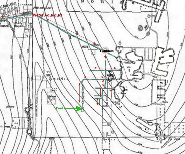
Complete Map of the Temple Mount in Jerusalem, with southern water channels.
Water Channels (conduits) at the southern end of the Temple Mount.A quote from Warren's writings. "Access was obtained to the water conduits through a hole in one of them in front of AI-Aksa, and they were traced as far as possible, but the rubbish has fallen in in many places, and with the exception of two or three the branch ducts are too small to admit of the passage of a man. From the number of openings seen, there must be a perfect net-work of small subterranean channels in this part of the area, but without excavation they could not be traced. It is very difficult to judge of the age of these conduits, but where cut in the rock they have been probably made at the same period as the cisterns, as the one which enters the large cistern east of the "Great Sea,' and this was found to be in connexion with another conduit leading down to the "Well of the Leaf" and one running up in the direction of the Fountain Al-Kas (the cup); the connecting branches were in part cut out of the rock, in part made of masonry and roofed with large stones. Besides these conduits which appear to have been in connexion with the aqueduct from the Pools of Solomon, there are number of others apparently of more modern construction for collecting the surface drainage into the cisterns: No regular system of water channels could be found in the northern part of the area, except those of very modern date, but it is not improbable that such may exist."
I saw
immediately that it was the ancient water
system for the Temple.
I knew at a glance
that my
diagram of the Temple
complex would fit over the top of it perfectly, revealing what Solomon
had done.
I
searched
the Internet and finally found a copy of the original map. Pasting it
into a
paint program and overlaying it with my diagram of the Temple complex,
which I had
created in 2000, was great conformation that my diagram was correct.
 .
.


SW
corner of the Temple Mount. Water
flowed from the Lower Aqueduct to the water system. The pool was used
to submerge the giant Copper Laver for the Priest to wash their hands
and feet throughout the day.
The Lower Aqueduct
The aqueduct coming from Bethlehem (Solomon's Pools) that entered the temple mount over Wilson's Arch was called Ein Etam by the Jews. This Lower Aqueduct was built by Solomon bringing water to the Temple from the Etam Spring (Ain Atan) near Solomon’s pools. The Jerusalem Talmud (Yoma 31) shows that a conduit ran from Atan (Ain Atan, Ein Etan, Spring Etam) to the Temple.
Abaye, a Jewish sage of the 4th century was quoted as saying; "If these orifices be now opened, the water rushes in from all sides, and the marble floor of the sanctuary is washed clean of the blood of the sacrifices, if it be ever so much, and thus cleansed of itself, and in the easiest manner. There can be, moreover, never a want of water in these artificially constructed tubes, as it is conducted hither FROM A LARGE NATURAL SPRING (ETAM), which to a certainty can never dry...
Tosefta Pesachim, Ch. 3, Par. 12, "How is the Azara cleaned? Seal the area and let the water from the aqueduct enter till it becomes clean like milk."(Quotes "The Hidden Secrets of the Temple Mount" by Tuvia Sagiv)
THE EIN ETAM IS 23 CUBITS HIGHER THAN THE AZARAH (the priest's court)". (Bab. Tal. Yoma 31a), From: "The Spring (Fountain) of Siloah...En Shiloach" (The Springs and Pools of Jerusalem) and that using the aqueduct waters derived from the Etam Spring the “high priest would immerse himself on the Day of Atonement” (Bab. Tal. Zebahim 54b) https://www.scribd.com/document/507657403/Yoma-31
Also
see: Who
Built the Lower Aqueduct?
Many of
the early
explorers drew maps with the Temple placed at the SW corner of the
Temple Mount
right where this water system was located. I made a short video
about the
water system and also
included information about the Trumpeting Stone, which was found at the
SW corner during the excavations.
Josephus wrote that the Place of the Trumpeting was within the Temple
complex,
which tells us that Herod’s Temple was not located in the City of
David, as some
claim. Water
System & Trumpeting Stone

Here
are the Maps
of a few of the Early Explorers. As
you can
see they agreed only
concerning the SW placement and disagreed about almost everything else.
Josephus gives the dimensions of the Herodian Temple complex as a square, each side one furlong (approximately 600 ft) in length. Josephus also states that the length of Herod’s Royal Stoa, located at the southern end of the Temple complex, was a furlong in length. How anyone can stretch the size of that Temple complex to fit the whole width of the Temple Mount is beyond me, because the Temple Mount is 995 feet wide, not 600 feet
So why
hadn’t Charles
Warren, Charles Wilson, or James Ferguson, and a few other early
explorers, understand
what this water system was? These
early explorers of the Temple Mount placed the Temple at this southwest
corner
because it was the only place on the Mount that fit the description
given by
Josephus, a Jewish historian that lived in Jerusalem in the first
century. Josephus later
wrote about the Temple and its destruction in 70 CE in his books. These
early explorers also had
the evidence of the ruins deep within the Mount itself. They noticed
that it
was 600 feet, or one furlong, from the southwest corner to Triple gate,
the
exact measurement that Josephus had given for the width of the Herodian
Temple
complex. Why do I see it and they could not?
I have an advantage they didn’t have, which is the
excavations of the Ophel, which is located beyond the south
wall of the Temple Mount.
|
Locating
Solomon's Temple
by
Norma RobertsonNOW
ON VIDEO!
 BOOK Now available at Amazon Kindle books  "Locating
Solomon's Temple"
by Norma Robertson |