Locating Solomon's Temple
THE SOUTHWEST CORNER
Chapter Seven

The
“Place
of the Trumpeting” and the place above the Xystus reveal the real
location of
the Temple.
It
seems that the location of the Temple has always been hidden in plain
sight in the works of Josephus. Amazing!
We
learn of the Place of the Trumpeting through Josephus as
he describes the towers built by the Jewish Rebels who had taken over
the city
prior to its destruction. The rebels split into two groups and began
warring
against each other. One faction held the Temple and they built towers
on the
corners of the Temple compound to get a higher advantage for their
arrows. One of those towers was built above the Xystus. So first
we need
to find out where that was.
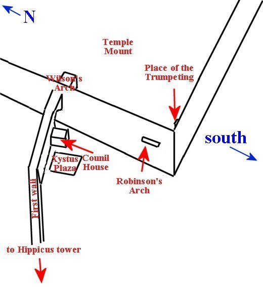
"Now that wall began on the north, at the tower called
"Hippicus," and extended as far as the "Xistus," a place so
called, and then, joining to the council-house, ended at the west
cloister of
the temple."
The Xystus was a plaza used for assembly, to hear public speeches made
from the
west wall of the Temple Mount.
The ruins of the Council House were discovered by Charles Warren in the
1860′s.
It is located near the Western Wall and the bridge over Wilson’s Arch.
The Place of the
Trumpeting was
located
at what is now thought to be the southwest corner of the
Temple Mount.


At the base of the southwest corner the remains of “The Place of the
Trumpeting” stone was found. It lay where it had landed after
the
destruction of the Temple.
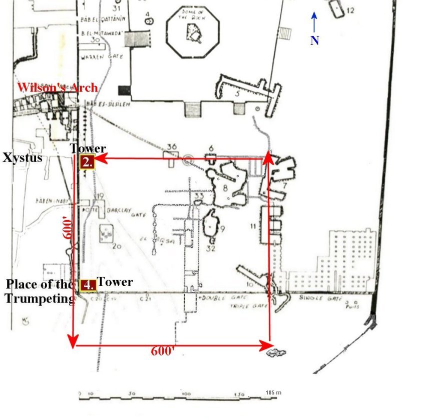
Josephus tells the location of the towers that the rebels built.

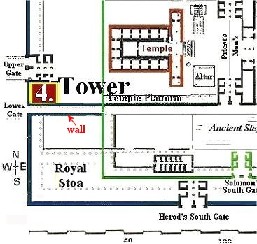
Josephus places the fourth tower at the corner of the “Place of the Trumpeting.”
Placing the towers on Warren’s map helps us to get our bearings.

To know where the temple was actually located on the Temple Mount we must combine this with what Josephus said about the size of Herod's Temple. It was a furlong in length and a furlong in width. So all we need to do is start at the tower built on the northwest corner above the Xystus of Herod’s Temple and measure a furlong of 600 feet southward.
It wasn’t until the Place of the Trumpeting stone was found that the puzzle could be put together, but I didn’t use the Trumpeting Place to show the location. Instead I used scripture, ancient survey maps, pictures of the Mount and Ophel, the writings of Josephus and the Jewish writings, such as the Mishna, etc. to discover this location.
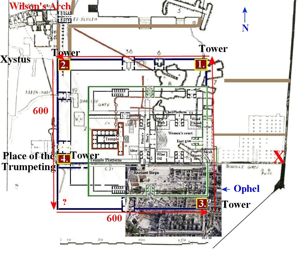
This graphic shows my
Temple diagram laid over the map with the towers.
 ……
……
This is in no way the southwest corner Josephus was speaking of.
The southwest corner would have been further down Ophel hill where the depth was greater. Not only would the wall appearing above the street have to reach the level of the rest of the temple, much taller than any other wall of the temple...but the buried part of the wall below the street would also have to go down much deeper in order to reach the bedrock in the Tyropoeon valley at the place I propose for the southwest corner. The only way this is possible is if the northwest corner of the Temple were at the place above the xystus pre destruction and of course pre Hadrian's reshaping of the temple mount area. This Temple theory is the only one which can account for all 4 towers in their proper places.
This is positive proof that the Temple was once located on the Temple Mount and not in the City of David or the Dome of the Rock.
South of this
second wall, the western half of the Ophel mound, excavations revealed
important data on the history of early Islamic Jerusalem. Four
edifices, about
90 x 90 meters each, were unearthed and data to the Umayyad period
(7th-8th
centuries CE). These buildings are probably part of an official
facility
erected by the Caliph Al-Walid, and shedding new light on the status of
Jerusalem during the Islamic period.
This stopped the
western half of the Ophel from being excavated down to the level of
that on the
eastern side.

This whole area is now called the Ophel
Archaeological Garden.

This is a photo of
the Western section of the Ophel as it looks today. All work has
stopped
and any ruins from an earlier time will remain hidden.
Return to Table of Content