

| Home | Temple Videos | On-line Book |
Herod's Temple in 3D | About the Author | |
|
Disputing the Dome of the Rock Theory
2.
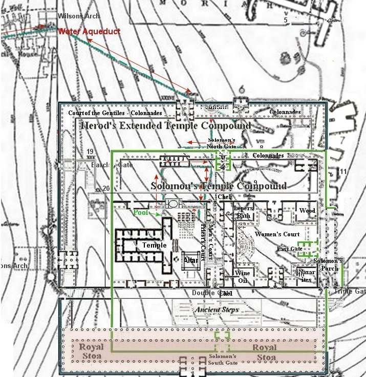
There is a discrepancy as to the size of Herod's Temple area
between what Josephus reports and what the Mishna tells us.
Josephus describes Herod's Temple compound as being square, a
stadia by a stadia or furlong by a furlong depending on the
translation. This is according to a Greek stadia/furlong
which is
approximately 600 feet X 600 feet. The Mishna,
when
speaking of Herod's
Temple
compound, says it is 500 X 500 cubits. "Mishna Middot," Chapter B, paragraph A.
Dr
Ritmeyer and Dan Bahat claim that the Mishna must have been speaking
about Solomon's Temple compound. Not only do they apply it to
Solomon's Temple compound, but they also declare it to be according to
a Royal cubit (long cubit 20.67"). Making this area approximately 858 x 858
square.
More than 250 feet larger than what Josephus claims as the
size
of Herod's Temple, and Solomon's Temple compound was a lot
smaller than Herod's, in fact Herod doubled the size
of
Solomon's Temple! Josephus also reported that
Solomon's
east wall was 400 cubits, not 500 cubits. Josephus
is using
a Greek cubit of 18 inches to describe the east wall of the Temple.
400c x 18"=7200 divided by 12"= 600 feet, which equals one
stadia. So Josephus is confirming the size of Herod's Temple in two
different ways.
Josephus says the Temple complex was "six furlongs, including fort Antonia"
The Wars of the Jews, Book 5, Ch 5
2. ...........The cloisters [of the outmost court] were in breadth thirty cubits, while the entire compass of it was by measure six furlongs, including the tower of Antonia; those entire courts that were exposed to the air were laid with stones of all sorts.
Josephus makes it very clear that Herod's Temple compound was a stadia/furlong by stadia/ furlong. In the above quote Josephus is including the open courts of both the Temple and Fort Antonia. It is one furlong/stadia for the length of the Temple, which he makes very clear before this, and one furlong/stadia for the length of Fort Antonia. If you were to walk around the outside of both the Temple and the Fort it would be 6 furlong/stadia around.
This makes the total, with both the Temple and the Fort Antonia, to be 1200 feet from north to south and 600 feet from east to west, according to Josephus. The size and shape of the huge Temple Mount, as it is called today, measures about 1560 feet from north to south and about 930 feet from west to east, with believed Fort Antonia located north of it and not included as part of the huge Temple Mount. That tell us that the true Temple Mount only took up a small portion of the land that they refer to as the Temple Mount today.
3. Water is a problem for the Dome of the Rock theory. There are many cisterns, but no fresh water supply. In fact an aqueduct is needed.
The Jerusalem Talmud (Yoma' 3 fol 41) says that a conduit ran from Atan (Ain Atan, Ein Etan, Spring Etam) to the Temple. Also, Tosefta Pesachim, Ch. 3, Par. 12. says "How is the Azara (Priest’s court) cleaned? Seal the area and let the water from the aqueduct enter till it becomes clean like milk."
I think that pretty much settles it. There is a conduit/aqueduct that was laid from Etam Spring to the Temple Mount that enters the Mount at Wilson's arch, but from there it was cut towards the south, away from the Dome of the Rock, meaning the Temple was located at the southern end of the Temple Mount.

4. From the lower aqueduct the water flowed into a man-made pool below the Temple court. A hole cut into the Court is where the copper laver was lowered into each day to fill the laver with fresh water. The aqueduct also filled the many mikvas for bathing. The water from the aquduct was used for cleansing the Priest court each night of the blood. All of this required a water system made up of water channels coming off the Aqueduct. There is no evidence of any water system in the Dome of the Rock area. Because the aquduct was always flowing with fresh water from an underground spring then the Temple was never without water. During a drought there would be no rain water filling the cisterns, leaving a Temple on the Dome of the Rock platform without any water at all.
However there is a water channel system south of the aqueduct.
5. Josephus also tells us about a man made moat that separated Fort Antonia from the hill to its north called New City (Bezetha) cutting the natural land bridge that connected the two hills together in half. To the east of this moat was a deep ravine. When the moat was full of water then no army could attack Fort Antonia from the north. This moat was excavated by Charles Warren and is shown on his map. The moat is located just north of the Dome of the Rock platform, making the Dome of the Rock area the location of Fort Antonia, not the Temple.
War of the Jews Book 5 Chapter 4
2. .................... It was Agrippa who encompassed the parts added to the old city with this wall, which had been all naked before; for as the city grew more populous, it gradually crept beyond its old limits, and those parts of it that stood northward of the temple, and joined that hill to the city, made it considerably larger, and occasioned that hill, which is in number the fourth, and is called "Bezetha," to be inhabited also.
It lies over against (across from) the tower Antonia, but is divided from it by a deep valley, which was dug on purpose, and that in order to hinder the foundations of the tower of Antonia from joining to this hill, and thereby affording an opportunity for getting to it with ease, and hindering the security that arose from its superior elevation; for which reason also that depth of the ditch (moat) made the elevation of the towers more remarkable. This new-built part of the city was called "Bezetha," in our language, which, if interpreted in the Grecian language, may be called "the New City."
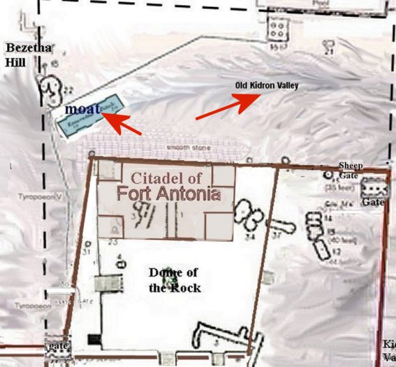
The Dome of the Rock theory places Fort Antonia north of the excavated Moat, not south of it as Josephus claims.
6. Josephus also points out that Fort Antonia was on the highest hill. The Dome of the rock platform is on the highest hill of the eastern ridge.
The Wars of the Jews, Book 5 chp 5,8 "for the temple was a fortress that guarded the city, as was the tower of Antonia a guard to the temple; and in that tower were the guards of those three. ........that hill on which the tower of Antonia stood was the highest of these three.
The elevations for the peak of the hill under the Dome of the Rock and the hill under the school at the northwet corner on the topography maps show that the highest hill of the whole eastern ridge is that of the Dome of the Rock.
7. The recent discovery of the Akra (acra) in Givati parking lot just south of the Temple Mount has to be denied by Leen Ritmeyer because it is too far south of the Dome of the Rock and in too low of a position to see into the Temple during the time of the Hasmoneans (pre-Herod Temple). Also Eilat Mazar's Amazing Discovery of the Solomonic Wall and the Royal Complex of Solomon's Palace has to be denied because it is also too far south of where Leen Ritmeyer places Solomon's Temple compound.
These problems do not exist for a lower, more southern, Temple location on the Temple Mount.. Please read, or watch the videos, below.
Update;
9/17/2018
The picture below was taken in the 3D
program where I have built Herod's Temple and Fort Antonia. It is built
to specs with 1 meter size blocks. Measurements for the Temple and the
Fort that I used are according to Warren's map using the legend at the
bottom, which is in meters. 1 meter = 1 block. (In
the picture
Fort Antonia is on the Dome of the Rock platform according to my
theory. So you will have to imagine the Temple on the platform as
is
proposed by Leen Ritmeyer.)
The picture below is looking west from
the Mount of Olives. With the Dome of the Rock theory the Temple
and
upper court are on the Dome of the Rock platform. Fifteen steps down
from that level is the level of the women's court, for both Solomon's
Temple and Herod's Temple. But there is a big problem that Leen
Ritmeyer doesn't mention. It has to do with the three buildings
that
are just below the ground level of the Temple Mount today,
identified
and measured by Charles Warren in the 1800's. The southern most
building actually has it roof just above the ground level. This
building is 44 feet deep. Making ground level in Solomon's time
around
40 feet lower, on the eastern side of the platform, than the surface of
the Temple Mount of today.
Ritmeyer also identified the lower portion of the east wall, of today,
as being built by Hezekiah, along with the original gate, which is
located under the Muslim built east gate that we see today. In
Nehemiah we are told that this original gate was at the north end of
the Hezekiah city wall, which Nehemiah rebuilt and the gate was called
the Miphkad gate.

Ritmeyer claims that Solomon's women's court was built at ground level
of the Temple Mount as it is today. This is not possible because
Solomon's Temple was
built (950 BC) before Hezikiah (700
BC) built the east city wall, gate,
and the 3
buildings seen on Warren's map. How could these 3 buildings be
built under the women's
court after the women's court had already been built 250 years earlier?!
This, once again, proves that the Dome of the Rock theory was not the
location of Solomon's Temple.
Looks
good on paper but not in 3D
Below is the map of Ritmeyer's Temple over Warren's topographical
map.
Notice the 3 buildings are directly below where he claims the women's
court once was.

Three buildings in blue green and pink.

I drew this imaginary diagram. The
Women's court would have had to be built on a steep slant of the
mountain! I don't think this is very practical. :)
Norma
|
Locating
Solomon's Temple
by Norma Robertson NOW ON VIDEO!
 BOOK Now available at Amazon Kindle books |
