| Home | Temple Videos | On-line Book |
Herod's Temple in 3D | About the Author |  |
 |
By Norma Robertson
Solomon built the Temple of God around 960 BC. Water was very important for the Temple to cleanse the court every evening of the blood of sacrifices. Many believe this water came from the Gihon Spring. For this reason they place the Temple in the City of David above that spring. This theory was created by Ernest Martin and now promoted by Bob Cornuke and claimed as the true location. This becomes a huge debate. Was the Temple in the City of David or on the Temple Mount?
This article is not about Herod's Temple which came later in time. This is about Solomon's Temple and the Hasmonean dynasty, as to which one built the lower aqueduct. Even though the 2nd Temple was rebuilt by the Jews, returning from captivity in Babylon, and I could call it Zerubbabel’s Temple. I will just refer to it as Solomon's, because Solomon built the Temple on the threshing floor and the location of the Temple never changed.
Those that believe the Temple was built by Solomon in the City of David claim the Aqueduct was originally built by the Hasmonean around 160 BC, after the Maccabean revolt ended. Then Israel gained independence for a short time. The Hasmonean did build upon the aqueduct but they were not the original builders. Solomon was. I will prove this through maps and ruins, and sources. But also through pure common sense.
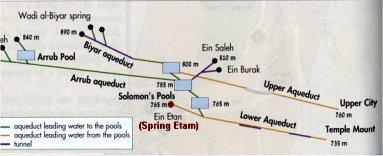
The lower aqueduct enters the Mount at Wilson's arch, as seen in white on the map below. The Hasmonean also built a fort at the north end of the Temple Mount to stop northern invasions and called it Fort Baris. It replaced the Towers that stood there before this time. Remember we are not interested in Fort Antonia right now. We are pre-Herod in this debate.
This map has Fort Baris at the north end of the Temple Mount and the
Temple of
Solomon located in the City of David. In between these two
is where the
Lower Aqueduct enters the Temple Mount.

Fort Baris was connected to the Temple by an underground passageway. So let's look at the map again. If Fort Baris was on the north wall of the Temple Mount and the Temple was in the city of David then that is one heck of a long tunnel! Makes no sense. The army needed to be able to get to the Temple fast.
I just know all he people that believe Solomon's Temple was in the City of David are thinking, "No. The whole Temple Mount was Fort Antonia. It is only 600 or so feet from there to the Temple." To them I say please remember that Fort Antonia wouldn't be built for another 140 years, or so, by Herod. All there was before that was Fort Baris that was located on the north wall that Nehemiah rebuilt. Fort Baris was not even close to the size of Fort Antonia.
So, the question is, what was the purpose for the aqueduct? (seen in white). Why would the Hasmonean build it at such great expense, and labor, if it didn't go to the Temple?? Nor did it go uphill to Fort Baris. Was it built to bring water to nothing? Again it makes no sense. Not only that, but they built an elaborate system of smaller water channels from the aqueduct leading even farther toward the south, the opposite direction from Fort Barris. Huston we have a problem! According to the City of David theory there was nothing in this area in the time of Solomon. There aren't even any water channels continuing down to the City of David from the aqueduct. Evidently they think the aqueduct served no purpose at all.
The fact is, it was David's Palace that was built at the north end of the City of David, above the Gihon Springs, not the Temple. This site was excavated by Eilat Mazzar. Many ruins of walls were found, none of which fit the shape of the Temple. So the Temple couldn't have been in that same spot as Martin and Cornuke claim.
Here is the order of the buildings that were south of Solomon's Temple. Below Solomon's Temple was Solomon's Palace and royal area, and south of that was David's Palace, which was at the north end of the City of David. Let's see how that works out on the map with the theory that the Temple was located in the City of David.
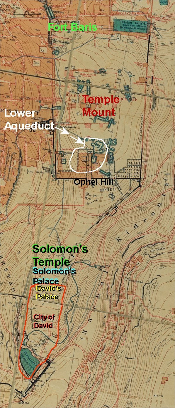
You can see in the map, that with the location of the Temple in the City of David, the size of the city becomes half it's known size. Again, makes no sense.
In my work, I have found that Fort Baris was farther south than they place it in the Dome of the Rock theory. A moat, that was excavated by Charles Warren in the late 1800's, and shown on all his maps, was north of the fort. Josephus writes that Fort Antonia was south of the moat. Fort Antonia was built to replace Fort Baris. Fort Baris and Fort Antonia were built on the old Nehemiah wall, that went along the north end of the Dome of the Rock Platform.
Once the fort is moved southward and the Temple is placed at Ophel hill, then it becomes feasible that an underground tunnel went from the fort to the Temple. The Temple is fed by the aqueduct and the smaller water channels go straight to the court to wash away the blood of the sacrifices. Solomon's Palace is against the Temple's south wall, right where Eilat Mazzar excavated and found the entrance to Solomon's Royal area.
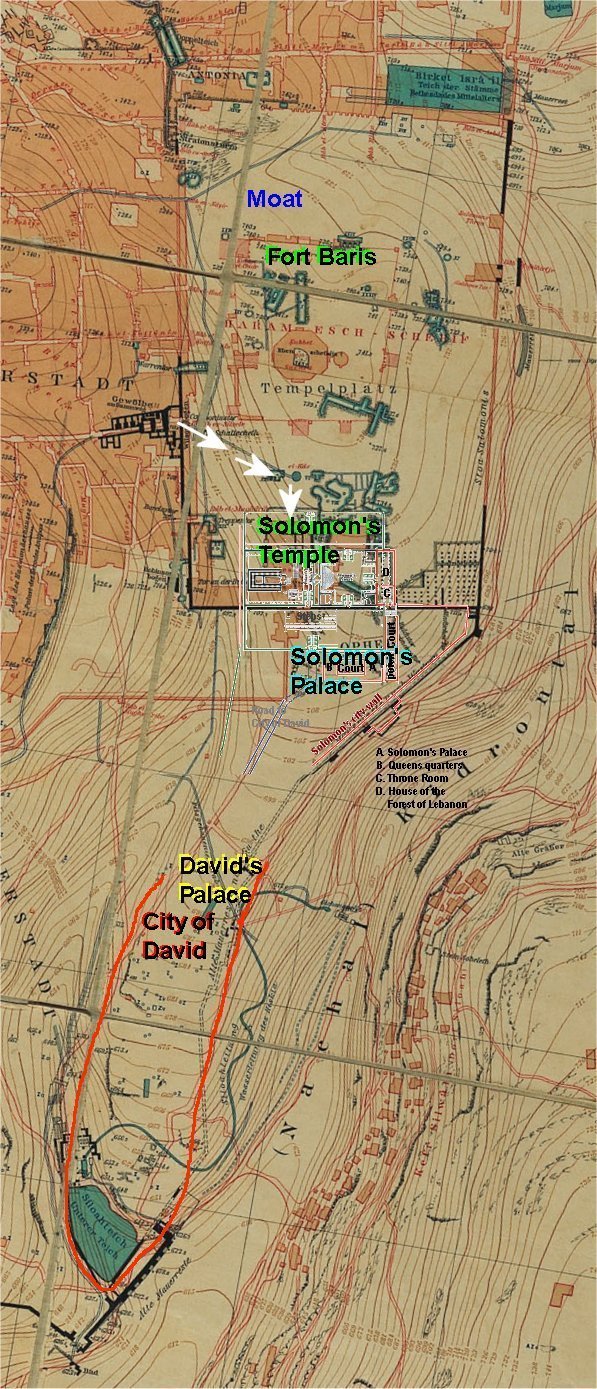
Notice how the City of David now returns to it's normal size when the Temple is on Ophel hill where it belongs.
With the Dome of the Rock Temple theory, and the City of David Temple theory, a problem remains, when they claim the Hasmonean built the aqueduct in 160 BC. In their theories the aqueduct brings water to nothing.

That fact should haunt them in the middle of the night. It should make them question whether or not Solomon actually built the aqueduct to bring water to his Temple. It is common sense that he did, but they don't question it because it ruins their theories.
In my theory, Herod built Fort Antonia to replace Fort Baris and he also extended Solomon's Temple courts to the North, West and South. This made the Temple compound one furlong by one furlong. 600 x 600 feet. Josephus included Fort Antonia in with the Temple calling it a complex, both together measured 6 furlong when walking around the perimeter. In other words 600 X 1200 feet. This places Fort Antonia as being built on the Dome of the Rock platform.
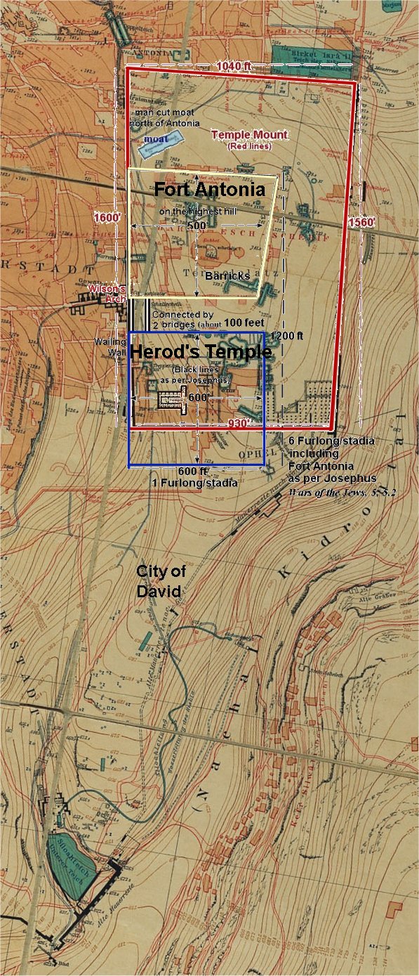
Wilson's map overlaid Herod's Temple and Fort Antonia diagram.
As you can see Herod's Temple is way too big to fit above the Gihon Spring.
To see the sources for this article please visit http://templemountlocation.com/