| Home | Temple Videos | On-line Book |
Herod's Temple in 3D | About the Author | End Times Videos |  |
 |
Photo Gallery
Herod's Temple in 3D
(feel free to copy these photos)
How can you know where the Temple was once located?
You listen to, and weigh, the known facts. Not just the facts people talk about that are selling a book or have an agenda of any sort, but all the facts. You start at the beginning with King David and the topography of the eastern ridge. What you don't want to do is look at the huge flat Temple Mount of today and try to fit it into this spot or that.
So go back to what David saw. A long slowly rising mountain. At the top was the peak of the mountain. According to Josephus it was 50 cubits high at the peak. War of the Jews Book 5, 5. Part way down was the Ophel which had a huge outcrop of stone. This is evident by the huge 200 foot wide, 22 feet high, steps that were cut into that protruding bedrock. Further south was the City of David where King David built his palace at the north end of the city. From the City of David he looked northward to where the threshing floor was located, where he saw an angel. A threshing floor was never in a city, but outside a city. It was never on the peak of a mount because of the higher winds.
read more

Herod's Temple
View from the cross on the Mt of Olives to the Holy of Holies.
From the Mt of Olives the soldier standing near Jesus could see the veil covering the Holy of Holies and see it disappear when the veil was rent in two when the lintel cracked.
Josephus wrote that the Temple was a furlong by a furlong, approx 600' x 600' square.
The southern court, which Josephus called the lower court, because it was on a lower part of the hill than the Temple house, was on Ophel hill outside the now existing south wall of the Temple Mount. The threshing floor was below the Al Aqsa Mosque


Together Herod's Temple and fort Antonia measured 6 furlong around. 600 x 1200 feet altogether
_______________________

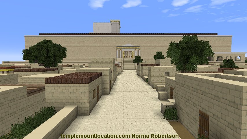
Entering Herod's Temple
On the left was the Menorah, in the center was the Altar of Incense and on the right the Table of the Shewbread.
The Arc of the Covenant, in former years, was behind the veil in the Holy of Holies.

_________

Cleansing the Priest Court of the sacrificial blood
They simply opened the Aqueduct at the north end of the court, which flowed from the Etem Spring near Solomon's Pools.

The water then drained down into the blood channel and out to the Kidron Valley via the city underground drainage ditch.
_______________________

It was located at the south end of the lower court, according to Josephus.
From east to west it was 600 feet long (one Greek furlong), the full length of the Temple.
__________

Red Heifer Bridge
The Red Heifer bridge begins at Solomon's porch (Triple Gate on Warren's map) and continued to the Mt of Olives.
The arches were staggered so that there would be air between the graves and the top of the bridge.
North of the bridge would have been full of ten's of thousands of animals on any given feast day.
The Hasmonean increased the size of this area up to the bridge because of the increase in population and most likely the need for more animals to be brought in for sacrifice-
The Ophel, to the south of the bridge, would have had many government buildings and shops for moneychangers, and the selling of doves and pigeons, etc. for sacrifice.
Fort Antonia looms in the background.
_______________________
View of Herod's Temple from the City of David
The south gate was a double gate, meaning it was wider than the other gates.
_______________________

Fort Antonia
A legion can easily fit here comfortably.
Located on the Dome of the Rock platform, plus the 130 feet Herod added on the west side when he filled in the Tyropoean valley.
_______________________

Overlooking the Temple from the highest tower in Fort Antonia
(looking south) The tower was 70 cubits (102 ft) according to Josephus. One could see inside the Temple compound from here
and see the top of the altar.
_______________________

Robinson's arch

Robinson's arch (the stepped bridge) looking east
_______________________

Fort Antonia
A view of Fort Antonia from the north.
The man made moat cut across the natural land bridge separating the north hill from the fort, leaving no flat ground nor means of attack from the north.
North of Fort Antonia was a 200' long 50' deep moat. The moat was cut into the bedrock of the natural land bridge between the two hills. To the west (right) of it was the Tyropoeon Valley and to the east of it was a deep ravine that emptied into the Kidron valley. The only way to take the Fort was to fill in the moat. This moat in this location was excavated by Charles Warren in the late 1890's. He also found sections of flagstone, which the Jews had covered the hill with, and found the ravine with a building built at the bottom of it.
Description by Josephus 70 AD
War of the Jews Book 5 Chapter 4
2.
.................... It was Agrippa who encompassed the parts added to
the old city with this wall, which had been all naked before; for as
the city grew more populous, it gradually crept beyond its old limits,
and those parts of it that stood northward of the temple, and joined
that hill to the city, made it considerably larger, and occasioned that
hill, which
is in number the fourth, and is called "Bezetha," to be inhabited also. It lies over against (across from) the tower
Antonia,
but is divided from it by a
deep ditch (moat), which was dug on purpose, and
that in order to hinder the
foundations of the tower of Antonia from joining to this hill,
and
thereby affording an opportunity
for getting to it with ease, and hindering the security that arose from
its superior elevation; for which reason also that depth of the ditch (moat) made the elevation of the
towers more remarkable. This new-built part of the city was called
"Bezetha," in our language, which, if interpreted in
the Grecian language, may be called "the New City."
Josephus writes that the design of
Titus was "to
take the Temple at the tower of Antonia;" and that for this purpose he raised
great banks; one of which was at the tower of Antonia, and the
other at about 20 cubits from it; and that for the purpose of
obtaining materials or filling up the immense fosse and ravine to the
north of the Temple, he
had to bring them from a great distance; and that the country all round
for a distance of 19 or 12 miles was made perfectly bare in consequence.
The End of the First Century Streets built by the Herodians.
View from west to east. All trace of a western wall ends here at what is called The Market Place in the western wall tunnel.
The Market place continues west with a line of 9 columns. The western wall ends as the quarry begins. The quarry is bedrock, where they cut the large stones from for building this part of the wall. Charles Warren explored the area in the 1890's and found no trace of a northwest corner beyond this place and no trace of a northern wall in the traditional place, further north from here. This places Fort Antonia on the Dome of the Rock platform. Not the Temple.
