Research Menu
Water Channels on the
Temple Mount
Warren map
Finding this map on-line many
years after I began this web site
was
a wonderful confirmation!
And
I believe it is the last
puzzle piece needed in putting this picture together.

As
you can see there are NO water channels
leading to the Dome of the Rock area.
The Lower Aqueduct
The
aqueduct coming from Bethlehem (Solomon's Pools) that
entered the temple mount over Wilson's Arch was called Ein Etam by the
Jews. This Lower Aqueduct was built by Solomon bringing water to the
Temple from the Etam Spring (Ain Atan) near Solomon’s pools. The
Jerusalem Talmud (Yoma 31) says that a
conduit ran from Atan (Ain Atan, Ein Etan, Spring Etam)
to the Temple.
https://www.scribd.com/document/507657403/Yoma-31
https://www.internationalstandardbible.com/E/etam.html
See
Etem
Abaye,
a Jewish sage of the
4th century was quoted
as saying; "If
these orifices be now opened, the water rushes in from all sides, and
the marble floor of the sanctuary is washed clean of the blood of the
sacrifices, if it be ever so much, and thus cleansed of itself, and in
the easiest manner. There can be, moreover, never a want of water in
these artificially constructed tubes, as it is conducted hither FROM A
LARGE NATURAL SPRING (ETAM), which to a certainty can never dry...
THE EIN ETAM IS
23
CUBITS HIGHER THAN THE AZARAH (the priest's court)". (Bab.
Tal. Yoma 31a), From: "The Spring
(Fountain) of Siloah...En Shiloach" (The Springs and Pools of Jerusalem)
and
that using the aqueduct waters derived from the Etam Spring the “high
priest would immerse himself on the Day of Atonement” (Bab. Tal.
Zebahim 54b)
Etam
was in reference to the Lower
Aqueduct
which entered
the Mount via the bridge (at Wilson's Arch).
The
other aqueduct was the Upper
Aqueduct
which was first built by Herod and re-built, or built upon by Pontius
Pilate and the 10th legion as stone pipes (part of a siphon
system).
Its destination
appears to be
'Hezekiah's Pool' in the Upper City.
Tosefta
Pesachim, Ch. 3, Par. 12,
"How
is the Azara cleaned? Seal the area and let the water from the aqueduct
enter till it becomes clean like milk."
(Quotes in red taken from "The Hidden Secrets of the Temple Mount"
by Tuvia Sagiv)
This
of course would also require a
duct to drain the
water which flooded over the azarah each day. That drain was
located
near the southwest corner of the ramp leading up to the altar where
they
burnt the offerings. This channel "blood channel" emptied into the
Kidron
Valley.
Can
there be any question left as to which spring the water for the Temple
came from? It came from Etam spring NOT the Gihon Spring.
The
Brazen Laver
There were two reason for "
living water" on the Azarah/priests
court; one was to cleanse the court daily and the other was to fill the
brazen laver, which was a very large pot or tub on a pedestal which
held
a great amount of fresh "living" water. It had faucets around the sides
of it which could be opened for the cleaning of hands and feet for the
purpose of purity. It had to be emptied each night and
refilled in
the morning with fresh water. During the second temple period
a new
way of filling the laver was devised called the muchni.
The
Muchni
Ben Katin, one of the High
Priests who served during
the era of the Second Temple, devised a system for retrieving the water
each morning using the mechanism of the muchni, meaning "machinery," The
laver was submerged into a specially-made pool under the court.
The
laver was then hoisted up by the first priest in the morning.
Note: Muchni is also a name for
a
type of wagon wheel.
Wheels installed under the laver may have been needed to roll it from
it's
place; between the altar and the House of God, over to where
the
underground pool was located under the azarah for refilling it. The
"hoisting
up" of this large pot full of many, many gallons of water by just one
priest
would have required an elaborate pulley system.
I
believe this is the pool, that I have marked with
the green arrow on the map below, would have been used for
filling
the Brazen Laver.
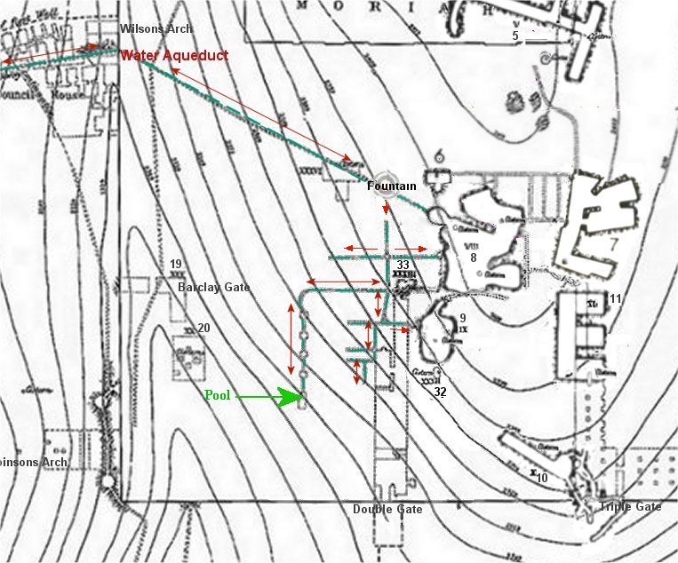
When I
laid my Diagram over this map the pool was right
next to the Temple!
Another branch of the water
channel ended at the Priest
Court, and another went to where the chamber of the Hearth would have
been located for filling the Mikveh below it.

I'd like to give my opinion on a the channel
running north to south,
red
arrow, that ends abruptly. Since we know water doesn't flow
uphill then this section of the channels must have begun at the
aqueduct
and flowed downhill from there.
UNDER DOUBLE GATE HALLS below the Al
Aqsa Mosque
Recently
photographs from 1927 have
been released that
show a Jewish mikveh (bath) under the Al Aqsa Mosque.
 It is located
somewhere beneath the
double passage halls
below the Al Aqsa Mosque. Notice the measuring rod and ladder on the
floor
of this Mikveh, which shows its immense size. In my theory this Mikveh
would have been located under the Chamber of the Hearth. This shows us
that water channels went down to this level beneath the Priest court.
It is located
somewhere beneath the
double passage halls
below the Al Aqsa Mosque. Notice the measuring rod and ladder on the
floor
of this Mikveh, which shows its immense size. In my theory this Mikveh
would have been located under the Chamber of the Hearth. This shows us
that water channels went down to this level beneath the Priest court.
"We
theorized in October that the American Colony photographer
gained access to the area under the al Aqsa Mosque, partially destroyed
in the 1927 earthquake. Nadav Shragai, a scholar on Jerusalem sites,
reported
in a Yisrael HaYom article last year, that Robert Hamilton, director of
the British Mandate Antiquities Authority, had explored under the
mosque
at the time. He "photographed, sketched, excavated and analyzed" what
he
saw. But he promised the Islamic Authorities, the Waqf, that he would
make
"no mention of any findings that the Muslims would have found
inconvenient"
such as findings from the time of the Jewish Temples."
israeldailypicture.com
A
Dome of the Rock
location for the Temple would have made it impossible to supply running
water to the Temple.
According
to
the Mishnah, the way that blood was washed from the floor of
the
Priest's Court where sacrifices were performed was to open
the floodgate
of the aqueduct directly into the court.
The
Jerusalem
Water Aqueduct
"The water canals that
supplied Jerusalem began in the area of the Hebron mountains, passed
through
the Solomon's Pools near Bethlehem, and flowed to Jerusalem. The lowest
canal reached the Temple Mount through the Jewish Quarter and the
Wilson
Bridge. According to the ancient authorities, the water conduit
supplied
water to the High Priests' mikveh (ritual bath) located above the Water
Gate, and it also supplied water for the rinsing
of the blood off the Azarah (Priests court). Portions of this
aqueduct are plainly visible to this day.
"Living water," that
is fresh flowing water, not water from a cistern, was required for the
ritual bath (mikveh) used by the temple priests, and for the washings
of
the temple in connection with the sacrifices.
A survey of the level
of the aqueduct reveals that if the Temple had been located at the same
elevation as the present Dome of the Rock shrine, the aqueduct would be
too low to serve either the Azarah or the Water Gate.
" Lambert Dolphin

Part
of the aqueduct is still in existence. . In fact,
remains of
the aqueduct
itself show that after entering the Temple Mount across Wilson's Arch,
it turned to the southeast towards the Al Aksa fountain and its
associated
cisterns which points to a lower location for the Temple.
Also see: Who Built the
Lower Aqueduct?
Locating
Solomon's Temple
by Norma Robertson
NOW ON VIDEO!
BOOK
"Locating
Solomon's Temple"
by Norma Robertson
|
Created Aug 2007


