Locating Solomon's Temple
THE OPHEL EXCAVATIONS
beyond the south wall
Chapter Five
The Ophel mound
excavations began in 1968 soon after Israel got control of Jerusalem.
At that
time these ruins lay beneath tons of earth, as we can see by this photo
taken
in 1923.

Side view of this
same area today reveals the ruins that were completely below ground
level.
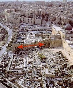
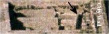
The wall cutting
through these ruins, cutting the Ophel mound in half, is the Muslim
city wall
(built in the fifteenth century). It meets up with the building erected
by the
Crusaders in the twelfth century.
The Crusader
building was built on the huge steps that lead up to Double Gate.
Josephus
described the Temple complex with many sets of steps leading up to the
inner
gates. Meaning the south section of the complex was terraced,
with steps
between the flat places.
These
ancient steps reveal a lot about the Ophel Mound. They were
originally cut into the bedrock, which protruded out of the earth. This
is
evidence of a gigantic rock mounding out of the ground at the top of
this hill.
I believe this rock to lead up to the threshing floor that King David
bought
and built the Altar to God on, and the place where Solomon built the
Temple.

Josephus tells us that Fort Antonia was built
on the
highest hill, which overlooked the Temple and the Temple overlooked the
City of
David. This to me means there were two hills on this eastern ridge of
Jerusalem.
“King David
purchased a threshing floor north of, and above, the City of David and
on that
foundation rock he built an altar to God. And before the altar his son
built
the House of God and in it he placed the Ark of the Covenant.”

Quote; The massive
stairs lead up to the platform. ["The large monumental stairway just to
the south of the Double Gate was excavated.] This stairway of 30 steps is
215
feet wide, paved with smoothly trimmed stones, and its FOUNDATION
STEPS ARE CUT INTO THE BEDROCK. From a wide plaza below on the
south…the STAIRWAY ROSE 22 FEET [sic 22-1/2 feet] to
the UPPER STREET
[the rampart/platform] in front of the Double Gate" [W. Harold Mare, The
Archaeology of the Jerusalem Area, p. 154]
Josephus
describes the upper courts and the Inner wall. "This court was
foursquare,
and had a wall about it peculiar to itself; the height of its building,
although it were on the outside forty cubits (58
ft), was hidden by the steps,
and on the inside that height was but twenty-five cubits (36 ft) for it being built
over against a
higher part of the hill with steps.
(War of the
Jews - BOOK 5, CH. 5)

If we add up the
numbers of 22’ + 36’ = 58
feet they
are the exact amount required to be the steps that rose up 22 feet and
hid part
of the wall from view that Josephus spoke of. Most likely they are the
steps
where Jesus over-turned the tables.
In the photo there
appears to be 14 deep steps and 16 shallow steps. The shallow steps are
for
“stepping-up” to the next level. The large steps are where one
would stop
and pray before ascending to the next step, the same as it was for the
steps in
the women’s court that led up to the eastern inner gate.
Josephus describes
the upper courts and the Inner wall.."This court was four-square,
and
had a wall about it peculiar to itself; the height of its buildings,
although
it were on the outside forty cubits, was hidden by the steps, and on
the inside
that height was but twenty-five cubits for it being built over against
a higher
part of the hill with steps. War of the Jews - BOOK 5, CH. 5)
So these
appear to be the steps that led up to the upper Gate (Double
Gate) of the inner wall, which encompassed the inner courts. At the top
of the
steps would then have been a terrace, called the chel ; (m. Kelim 1.8),
a 15
foot wide walkway, which was bounded by the walls of the inner court.
According
to Josephus, there were fourteen steps leading up to the Chel or
terrace.

The Crusader’s
building hides most of double gate and a large part of the western half
of the
steps and the Chel.
I found
even more proof in the ruins that the southern half of
Solomon’s temple complex and Herod’s extended courts lay beyond the
south wall.
Herod’s wall foundations would most likely be thicker than Solomon’s
older
wall.

The thinner wall
ends, and thicker begins, at the same place where Herodian's extended
walls
would have begun.
Earthquake
There is no way to
know which earthquake in Israel's history caused the twisted mess in
the midst
of the Ophel hill ruins, but it seems as though it happened sometime
before the
Muslims built their new city wall through the center of the ruins.

In the
picture below I rotated the collapsed area around 27 degrees, and put
things
back together a little to get an idea of how it would have looked like
pre-earthquake. This allowed me to further identify the position
of
Herod’s southern gate, which would have been 600 feet directly across
from his
northern gate. Once the ruins are adjusted like this then room for the
gate can
be seen.

The
city wall was built right through the center of it. As near as I can
tell, an
angled wall on the other side of the city wall, is the other half of
the gate.
I found a drawing of the oldest ruins of what I believe to be the Herodian South Gate (brown colored ruins) in the graphic below. The city wall was built right through the center of the gate and so parts of it are on both sides of the Islamic city wall.
.


Return to Table of Content