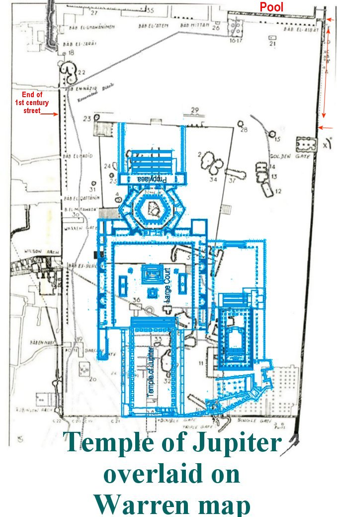
Locating Solomon's Temple
THE SOUTHEAST CORNER
Chapter Four

Moving
on to the southeast corner known as the section containing Solomon's
Stables.
What an
imposing site the southeast corner is. Trying to visualize the mount
without
this corner in the time of Herod is difficult, but that may have been
the case.
The upper portion of the wall, all the way around the mount, was built
by the
Muslims after 638 CE. Below that, is a portion that was constructed by
the
Romans and Bezintines.

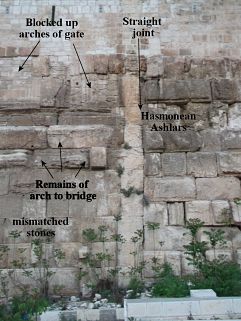
In the lowest
portion of the wall on the eastern side, there is a straight joint in
the wall
where the Hasmonean wall, second century BC, meets up with what is
believed to
be an Herodian wall built in the first century CE. The Hasmonean wall
ending at
this vertical line in the east wall tells us that their wall took a 90
degree
turn westward at this point in the original wall.
So the question is,
did Herod’s descendants build the wall from the Hasmonean wall all the
way
around to Triple Gate on the south wall, or was it built at a later
time?

Inside the lower
section of this wall it is made up of terraced vaults.

The vaults are
mistakenly called “Solomon's Stables” dubbed so by the Crusaders who
used the
upper vaults to stable their horses. Today that upper vault has been
made into
a subterranean Muslim Mosque.

In
November 1868, Captain Charles Warren of the British Royal Engineers
dug a
vertical shaft around 90 feet down to the bedrock at the SE Angle of
the Temple
Mount Platform. This sketch shows what they found.

Herod stones are
unique in that they have a "marginal dressing," meaning that each had
a frame or margin chiseled around its edge. In a Herod/Herodian built
wall we
would see stones that have matching equal margins, which the southeast
corner
does not have.
This wall is made
up of recycled Herod/Herodian stones taken from somewhere else and used
to
build this wall. Some of the stones even have mason marks on them. The
masons
cut and marked the stones at the quarry so that the builders could
place them
properly to create the specified building, much like a prefab house
today.
This is a quote
from the PALESTINE EXPLORATION FUND. Patron— THE QUEEN. Quarterly
Statement.
JANUARY 1869— SEPTEMBER 1870.
“34 LETTER OF MR.
EMANUEL DEUTSCH.
I must now
speak somewhat fully on a subject which has engaged public attention
for some
time, and has already given rise to many conjectures — namely, the "
Writings," either painted on, or cut into, the stones, discovered
lately
on the bottom rows of the wall at the south-east corner of the Haram,
at a
depth of about 90 ft, there where the foundations lie on the live rock
itself.” -end quote
(Note: He
believed them to be based on Phoenician letters)
This section of the
east wall was not built by Herodian builders.
Compare the sketch
to the photo taken of the Southwestern corner, a wall proven to have
been
constructed by Herodian builders. See how the marginal dressing in the
photo is
the same on every stone, unlike the mismatched stones in the sketch of
the
southeast corner.

And of course the
southeast corner of Solomon's stable didn't exist when Nehemiah was
rebuilding
the city wall. At that time one would have been able to see the
east wall of
triple gate (Solomon's Porch) perched on the very edge of a steep hill.
Also a
bridge crossing the Kidron Valley (Bridge of the Red Heifer) would have
started
at Solomon's porch/portico, which contained the east gate, and
continued across
to the Mount of Olives.
Who Built the
Southeast Corner and Why?
This section of the
east wall was most likely built by the Roman Emperor, Hadrian, around
130-35
AD. He needed an enlarged, flat, mount to build the Temple of Jupiter
complex
on.
Here is an example
of the Temple of Jupiter complex in Lebanon, just to get an idea of its
size
and shape.

Temple of
Jupiter-Lebanon
Very interesting
how well his design fits the same shape and placement of both the Dome
of the
Rock and also the Al Aqsa.
To accommodate such
a huge Temple, similar to this one, Hadrian's builders would have
needed to
build up and increase the size of the mount at the southeast
end. If
this theory is correct then the best way to do this would be for
Hadrian to
build his south wall on the pre-existing platform at the top of the
huge steps
of the Ophel. The ruins of a partial wall, would have already
existed and
he need only rebuild it and extend it to the east.

That ruined partial
wall would have once been the inner wall surrounding Herod's Temple and
priest
court. Hadrian would need only to build up, and extend that (yellow)
wall to
the Triple Gate building and then create a new Southeast corner (green
wall).
As you can see if
he tried to take his enclosure any further to the south he would
have to
build even deeper into the Kidron Valley. To rebuild the outer wall of
the
former Temple of the Jews (white writing on the photo) would not work
for that
reason. This would mean that the Roman's are responsible for the size
and shape
of the Mount we see today. To build up the southeast corner to
accommodate the
Temple of Jupiter complex would require tearing down the bridge from
the
straight joint upward to the Portico of Solomon and then building the
terraced
vaults. It would require building a gate into this wall, which
could then
be reconnected with the bridge outside of the wall. The
walled up
arched openings can still be seen in the wall today near the straight
joint.
A low wall believed
to have been built possibly by Herod's grandson, extended all the way
from
triple gate down to meet up with the Nehemiah wall. The Red
Heifer Bridge
would have gone in between that wall and the Hasmonean wall.
This section of the
east wall was not built by Herodian builders. And of course the
southeast
corner of Solomon's stable didn't exist when Nehemiah was rebuilding
the city
wall. At that time one would have been able to see the east wall of
triple gate
(Solomon's Porch) perched on the very edge of the steep hill.
If my theory is
correct for the location of the Temple then this bridge would have
traversed
the Kidron Valley and from there one could look back and straight
through the
east gate to the Holy of Holies.
The Jewish cemetery
is located directly across from the southern end of the Temple
Mount.
Jewish people of the time desired to be entombed directly across from
the East
Gate. In a direct line from this arch in the wall are the tombs
of, what
is called the Tomb of Zechariah. This tomb was actually built in the
first
century for the High Priest. It would have been below the Bridge. The
Jewish
Cemetery continues outward from there and one must wonder why the early
Jews
would be buried across from the south end of the mount, and not across
from the
supposed Golden Gate in the east wall of today, or across from the Dome
of the
Rock itself.

There is so much
more to be learned from the walls of the Temple Mount. It just requires
the
excavations to continue.
This is a digital
illustration of what Herod’s Temple Mount might have looked like in 70
AD.
Notice Triple gate (Solomon’s Portico) and the Red Heifer Bridge cross
the
steep valley to the Mt of Olives.
Of course the
Temple house was completely destroyed in 70 AD, long before the ground
level of
the Temple Mount was raised to its new level.

This is a digital
illustration of what Herod’s Temple Mount might have looked like in 70
AD.

Of course the
Temple house along with all the new buildings of Herod’s Temple were
completely
destroyed (not one stone upon another) in 70 AD, long before the ground
level
of the Temple Mount was raised to its new level.
Notice;
Triple gate (Solomon’s Portico) and the Red Heifer Bridge across the
steep
valley to the Mt of Olives.
Return to Table of Content